Data Centers: Power Plants & Emissions
Several data center projects in Iron County and nearby Millard County plan to make their own electricity on site with natural gas engines or turbines. This page collects what the public filings say. Updated October 27, 2026.
Map
Oct 26, 2026: The Iron County Commission voted to repeal the data center moratorium and adopt new data center rules (Salt Lake Tribune, Oct 27, 2026). The moratorium is no longer in effect.
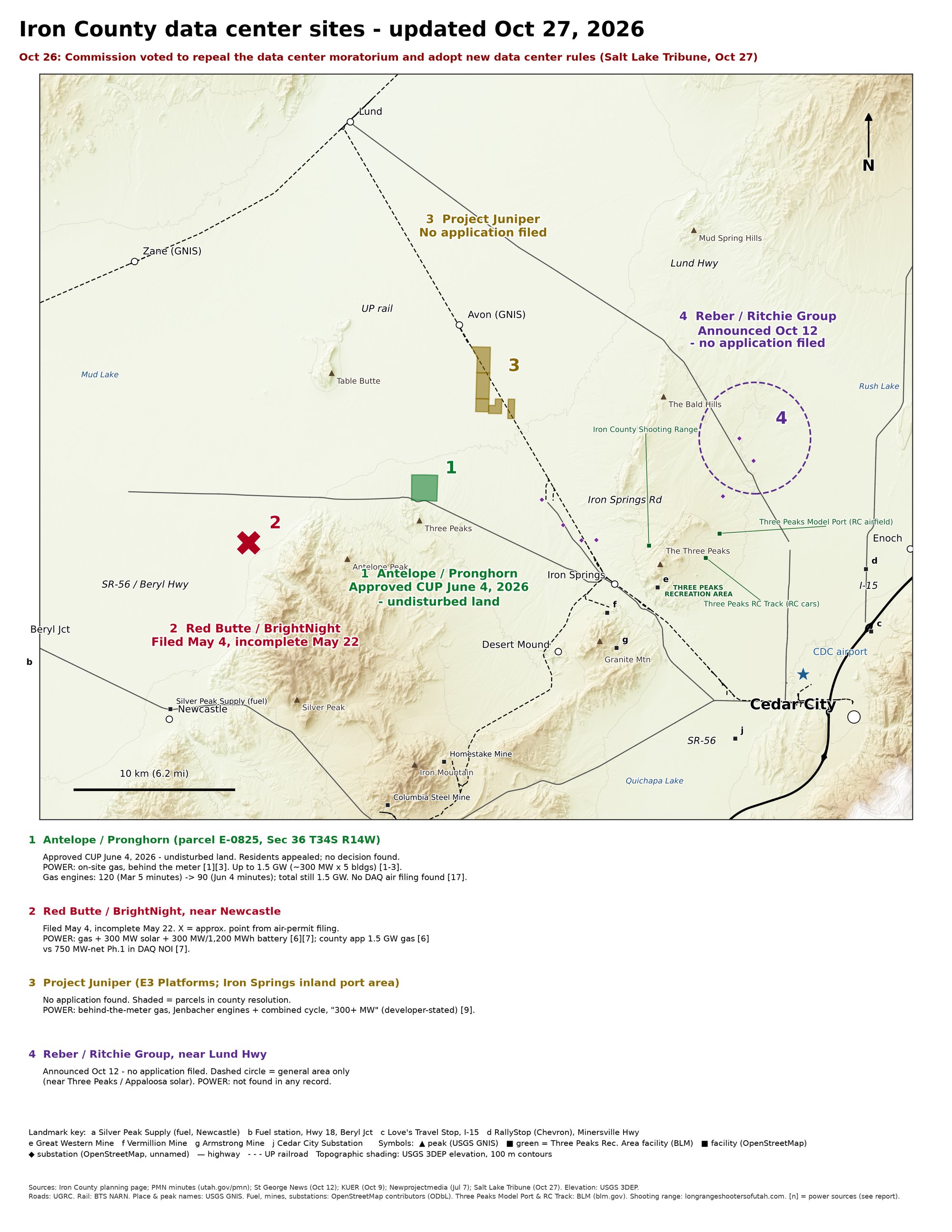
Where people live
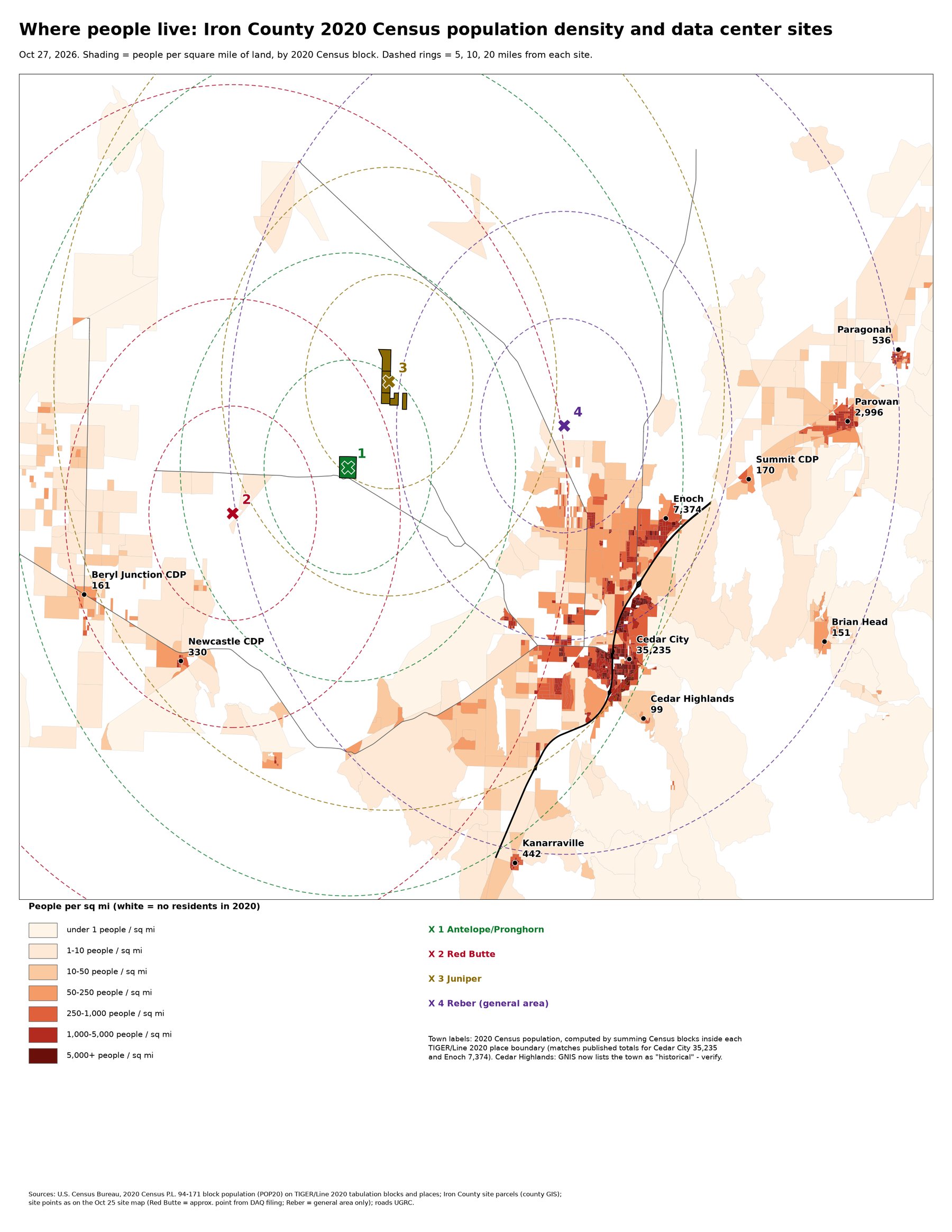
Nearest residents
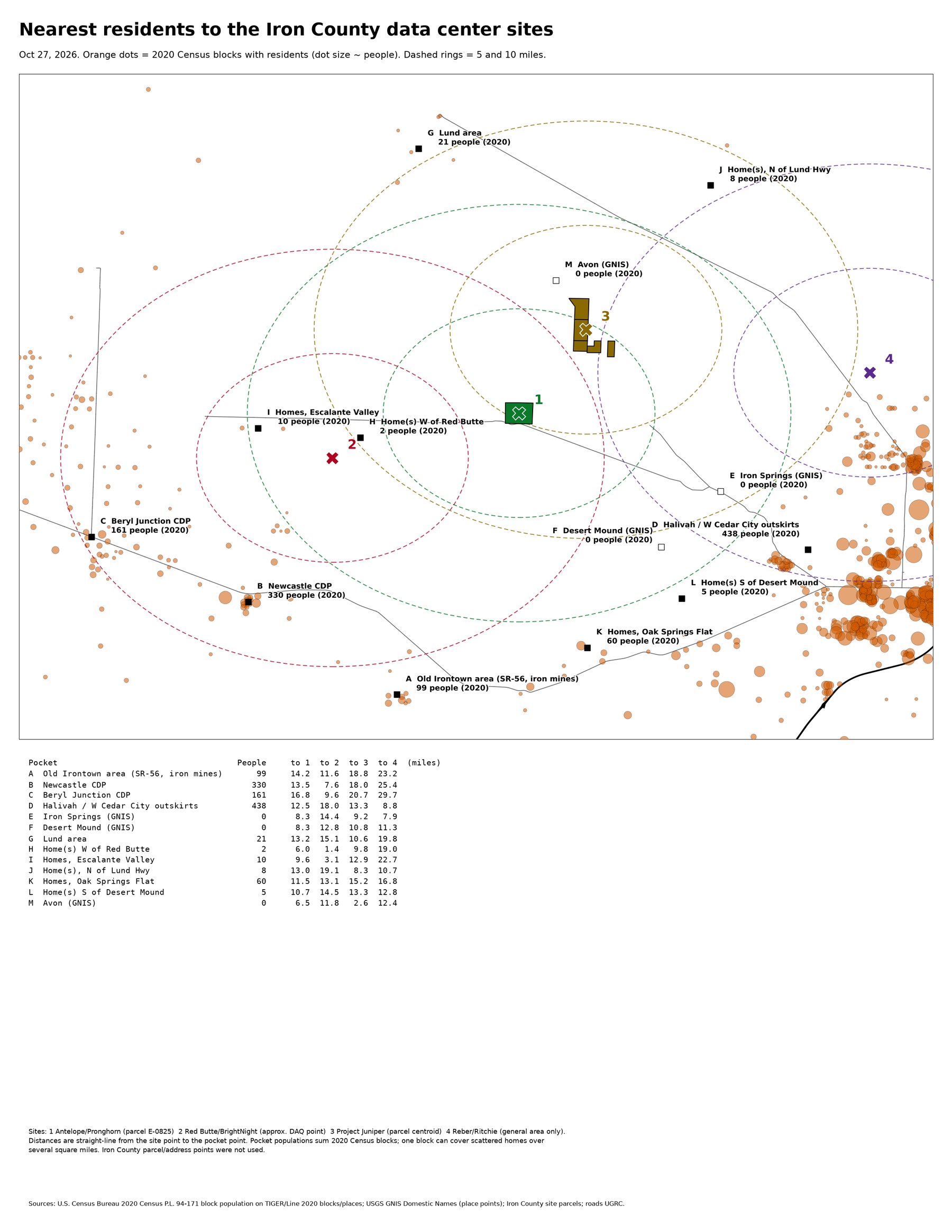
Engine counts by site
| Site | County | Gas engines | Diesel backups | Status | Source |
|---|---|---|---|---|---|
| Antelope (Pronghorn) | Iron | 90 or 120 Verified | Some; count not stated | County approved Jun 4, 2026; appeal pending; no air permit filing | Iron County Planning Commission minutes, Jun 4, 2026 (5 buildings × 18) and Mar 5, 2026 (5 × 24) |
| Red Butte (BrightNight) | Iron | 0 or 44 Wärtsilä. The engines are one of three options; the other two use turbines. Third-party copy Unverified | 4 (2 generators, 2 fire pumps) | Air application not on the state status list | Air permit application dated July 3, 2026 (third-party copy) |
| Juniper | Iron | Not published | Not published | No filing found | Developer site |
| Joule Capital, Site 1 | Millard | 69 Verified | 69 | Permitted Jan 22, 2026 (~175 MW) | Utah DAQ DAQE-AN162810001-26 |
| Joule Capital, Power Station 5 | Millard | 69 Verified | 69 | Permitted Sep 11, 2026 | DAQE-AN162930001-26 (third-party copy; listed on the state permit status list) |
| Joule Capital, Sites 2, 3, 4, 6 | Millard | Not verified Unverified | Not verified | Permitted Sep 11, 2026 | State permit status list |
Totals Computed
- Iron County gas engines only: 90 to 164
- Iron and Millard gas engines: 228 to 302
- Gas and diesel engines at verified sites: 366 to 444
These totals don't count Juniper, Antelope's backup generators or Joule Sites 2, 3, 4 and 6, because those counts haven't been published or verified.
Permitted and proposed emissions (tons per year)
| Pollutant | Joule Site 1 (69 engines) Permit | Red Butte: 15 Siemens turbines | Red Butte: 20 PE6000 turbines | Red Butte: 44 Wärtsilä engines |
|---|---|---|---|---|
| Nitrogen oxides (NOx) | 230 | 233 | 237 | 248 |
| Carbon monoxide | 203 | 247 | 239 | 210 |
| Volatile organics | 107 | 135 | 139 | 178 |
| Fine particulates | 61 | 177 | 248 | 145 |
| Hazardous air pollutants | 126 | 10 | not extracted | 50 |
| Formaldehyde | 69 | 4 | not extracted | 20 |
| Greenhouse gases (CO₂e) | 865,632 | 2,036,706 | 2,387,084 | 630,928 |
The Red Butte figures come from the July 2026 application Third-party copy, which the state hasn't reviewed yet. Antelope has no air filing, so it has no emissions figures. Sources: Joule permit; Iron County Antelope Q&A.
Per-engine limits (Joule Site 1 permit) Verified
- NOx: 0.06 g/hp-hr · CO: 0.08 g/hp-hr · VOC: 0.07 g/hp-hr
- Diesel backup generators: 50 hours a year of non-emergency use
Pattern: just under 250 tons of NOx
Every permitted or proposed configuration lands just under 250 tons a year of NOx (230 to 248). 250 tons a year is the major-source threshold that triggers federal Prevention of Significant Deterioration (PSD) review for most source types. Joule's 126 tons a year of hazardous air pollutants is over the 25-ton combined threshold, so it's a major source for those pollutants.
Carbon intensity Computed
From the greenhouse gas totals and plant capacity, our estimate is roughly 1,100 to 1,200 lb CO₂ per MWh for both Joule and Red Butte. That's in the upper part of the 800 to 1,250 lb/MWh range of the federal standards for gas plants. This assumes the plants run at full capacity all year.
Cooling and lubricating oil
- Permits: the permits don't describe engine cooling design or lube-oil storage. The only cooling equipment listed is Joule's 69 boiler-chillers, which make chilled water. Verified
- Red Butte application: two 2-million-gallon diesel fuel tanks (fuel, not lube oil). Third-party copy
- Wärtsilä 50DF (vendor figures): separate high- and low-temperature water cooling circuits, about 550 L of oil in each engine and an 8 m³ oil system tank per engine. Vendor figures
- Caterpillar G3520 (vendor figures): about 143 gal of oil, changed about every 1,000 hours. Vendor figures
- Estimates Computed: 44 Wärtsilä engines ≈ 93,000 gal of system oil; 69 G3520-class engines ≈ 10,000 gal per oil-change round. Which engine model Joule uses isn't stated here.
Gaps in the public record
- Joule's gas engines have no annual run-hour limit.
- No permit addresses what happens to the power plant if its data center closes.
- Antelope hasn't filed for an air permit, so it has no emissions numbers.
- Juniper's engine count, and the counts for Joule Sites 2, 3, 4 and 6, haven't been published or verified.
- No staffing or water-use figures were found for any site.